PERSONAL NARRATIVE
My interest in, and investigation of, the construction of Route 9 in Middletown was spawned by the great contradiction, and great irony, that characterizes its location. It blocks out the river that once served to make Middletown an international port, and yet, connects Middletown to the world in the same way that the river once had. It reminds us of the ways in which modernity has reshaped not only our ideas, but also the physical settings in which we do our thinking.
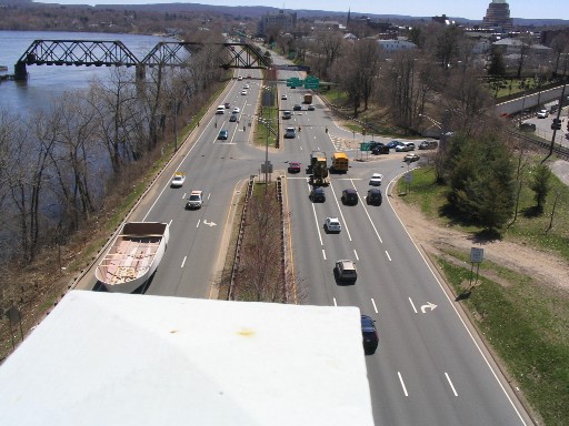
I began my research on the web with two sites detailing the driver’s experience of Route 9 and used their reference lists as a kind of guide for further examination.[1] I went to the Connecticut State Archives at the State Library in Hartford in order to look at the Highway Commissioner’s Biennial Report and others like it from the 1950s. Inspired by the image included above from this report, I took my own pictures of Route 9 from Harbor Park and the Arrigoni Bridge. Quite ironically, after close examination of the photos, long after their taking, fellow student Scott Quarrier pointed out that in one of them a ship was traveling down Route 9.
I later found on microfilm articles from the Middletown Press and the Hartford Courant that detailed proposed changes to the traffic light patterns on Route 9 in Middletown. At Olin Library I found a history of the Connecticut Department of Transportation, published by the department itself as part of its centennial celebration, and Stephen Goddard’s Getting There. After finding few resources at Olin’s Special Collections that were relevant to the time period in question, I continued my search for details on the highway project elsewhere. I called the Department of Planning, Conservation and Development for the city of Middletown but was redirected to the state department of transportation (DOT). After speaking with an engineer for current highway projects it was suggested that I go to the DOT Records Office in Newington, where I found fascinating blueprints from the 1950s and 1960s, but no real helpful information on the nature of the construction. Then at the suggestion of Dione Longley, I went to Russell Library’s Middletown Room where I was able to utilize the directories, their maps, and Elizabeth Warner’s Pictorial History of Middletown. It was here that I had to make an important decision about the direction that my project would follow. I had assembled many fragments of information about Route 9, but had yet to come up with an argument through which I could organize and present them.
My first attempt was tested using my in-class presentation – I wanted to get feedback on the notion that the waterfront was an industrial, commercial part of Middletown from the outset, and as such, when the river became an obsolete shipping medium it became expendable. As per the reaction from classmates, a closer reading of Goddard and further contemplation, I reformulated my argument about the idea that there was indeed no villain in the story of Middletown’s severance from the river; that larger forces were at work and society’s priorities were more responsible than any other single factor. I finally had a story to tell.
PART II HOME IMAGE ANALYSIS DOCUMENT ANALYSIS NEW ENGLAND LINK WORLD LINK
[1] “CT 9 Expressway, Historic Overview” at: http://www.nycroads.com/roads/CT-9/, and “Connecticut Roads” at: http://www.kurumi.com/roads/ct/ct9.html#9.